

Wetterstein Mountains and Zugspitze as a 3D Relief
Handmade in the Bavarian Alps.
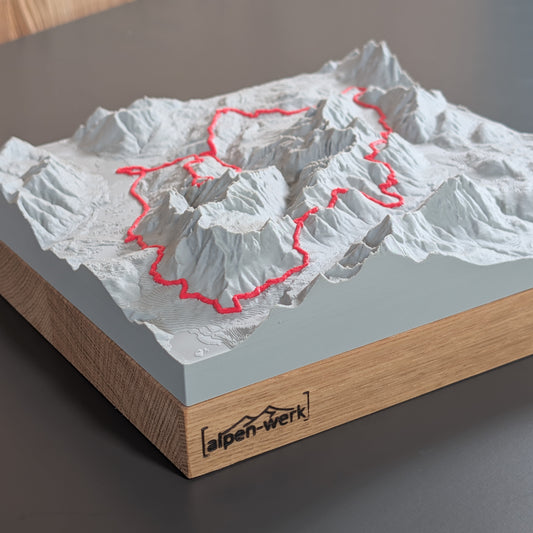
The Wetterstein Mountains and the Zugspitze as a 3D relief: Höllental, Reintal, Gatterl and Jubiläumsgrat as a single-color mountain relief, with a raised route or as a TrailMap of the ZUT. You set your own area around Garmisch-Partenkirchen in the configurator.
-
Mountain Model Classic | Alpspitze, Höllental, Zugspitze, Jubiläumsgrat
通常価格 $129.00 CADから通常価格単価 あたり -
Mountain Model Classic | Zugspitze with Jubiläumsgrat
通常価格 $129.00 CADから通常価格単価 あたり -
Mountain Model Classic | Zugspitzmassiv
通常価格 $129.00 CADから通常価格単価 あたり -
Mountain Model Classic | Zugspitze Gatterl
通常価格 $129.00 CADから通常価格単価 あたり -
Mountain Model Classic | Zugspitze
通常価格 $129.00 CADから通常価格単価 あたり -
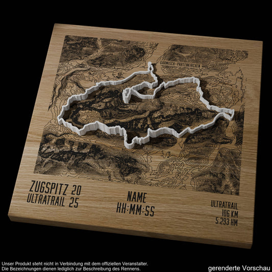
TrailMap | ZUT - Zugspitz Ultratrail | 2025
通常価格 $279.00 CAD通常価格単価 あたり -
Mountain Model Track | ZUT - Zugspitz Ultratrail | 2025
通常価格 $200.00 CADから通常価格単価 あたり -
Mountain Model Track | Zugspitze via Höllental
通常価格 $156.00 CADから通常価格単価 あたり -
Mountain Model Track | ZUT | Zugspitz Ultratrail | 2026
通常価格 $200.00 CADから通常価格単価 あたり -
Mountain Model Track | Zugspitze via Reintal
通常価格 $156.00 CADから通常価格単価 あたり -
Mountain Model Track | Zugspitze via the Gatterl
通常価格 $156.00 CADから通常価格単価 あたり -
TrailMap | ZUT | Zugspitz Ultratrail | 2026
通常価格 $226.00 CADから通常価格単価 あたり -
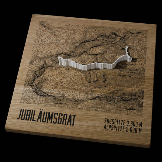
Mountain Model Track | Jubiläumsgrat | Zugspitze - Alpspitze
通常価格 $156.00 CADから通常価格単価 あたり -
TrailMap | ZUT Zugspitz Ultratrail | 2024
通常価格 $279.00 CAD通常価格単価 あたり -
Mountain Model Track | Zugspitze, Stopselzieher
通常価格 $156.00 CADから通常価格単価 あたり -
TrailMap | Jubiläumsgrat | Alpspitze - Zugspitze
通常価格 $279.00 CAD通常価格単価 あたり




The Wetterstein Mountains
Bavaria and Tyrol share the Wetterstein Mountains, or Wetterstein for short, a mountain group of the Northern Limestone Alps made mostly of Wetterstein limestone and heavily karstified. The Alpine Club guidebook distinguishes, among others, the Waxenstein ridge, the Blassen ridge and the Wetterstein ridge: the Blassen ridge runs from the Zugspitze to the Alpspitze, the Wetterstein ridge, the longest of the three, from the Gatterl to Mittenwald. Between the Blassen and Waxenstein ridges lies the Höllental; the Reintal is the valley of the Partnach between the Zugspitzplatt and the Partnach Gorge.
Zugspitze, Alpspitze and Hochwanner
At 2,962 m the Zugspitze is the highest mountain in Germany; the border with Austria runs over its west summit. Below the summit lies the Zugspitzplatt, a karst plateau, and on its flanks lie the Höllentalferner and the Northern Schneeferner glaciers. The Alpspitze, at 2,628 m, is considered the landmark of Garmisch-Partenkirchen. On the southern flank of the Reintal the Hochwanner reaches 2,744 m.
The routes up the Zugspitze
The first people documented on the Zugspitze were Josef Naus, his survey assistant Maier and mountain guide Johann Georg Tauschl in 1820. Their route through the Reintal is the easiest normal route and also the longest: through the Partnach Gorge, past the Reintalanger Hut, up to the Knorr Hut and across the Platt. At the Knorr Hut the variant from Ehrwald over the Gatterl joins. Through the Höllental you climb from Hammersbach through the Höllental Gorge and across the Höllentalferner. The third normal route leads through the Schneekar and the Stopselzieher, a natural erosion cave. The Jubiläumsgrat connects the Zugspitze and the Alpspitze; Ferdinand Henning was the first to traverse its full length, in 1897.
Ready-made reliefs of the Zugspitze and Wetterstein
- Classic, single color: Zugspitze, Zugspitze Massif, Zugspitze with Jubiläumsgrat, Zugspitze Gatterl and Alpspitze, Höllental, Zugspitze and Jubiläumsgrat.
- Track, the route as a raised line: Zugspitze via the Höllental, via the Reintal, via the Gatterl and through the Stopselzieher, plus the Jubiläumsgrat from the Zugspitze to the Alpspitze and the ZUT 2026.
- TrailMap, the flat map relief for runners: ZUT 2024, ZUT 2025, ZUT 2026 and the Jubiläumsgrat.
The ZUT, short for Zugspitz Ultratrail, is a trail running festival around Garmisch-Partenkirchen, first held in 2011. Its long course circles the Zugspitze and runs around the entire Wetterstein range.
Your tour in the Wetterstein
In the live 3D configurator you set the frame yourself, for example with Lake Eibsee or the Schachen in view. Your own route as a GPX file becomes a raised line on the 3D relief map in the custom Track relief. Add a base of oak or stone pine and, if you like, an engraving; everything is made in the Bavarian Alps.
A Zugspitze relief suits mountaineers after their first Zugspitze ascent, runners after the ZUT or families from the Werdenfels region. With the gift card the recipient chooses the area themselves.
Which routes up the Zugspitze are available as a Track relief?
Four ascents of the Zugspitze are available ready-made: via the Höllental, via the Reintal, via the Gatterl and through the Stopselzieher. Then there is the Jubiläumsgrat from the Zugspitze to the Alpspitze. Each route is shown as a raised line in the terrain; as a single-color Classic there are, among others, Zugspitze, Zugspitze Massif and Zugspitze with Jubiläumsgrat.
Can I put my own Zugspitze tour or my ZUT run on a relief?
Yes, with the custom Relief Track: upload a GPX file or add a link from Strava, Komoot or Garmin. The course is modeled as a raised 3D line, in red or white. For the ZUT there are also ready-made Track reliefs from 2025 and 2026 and TrailMaps from 2024 to 2026, with engraved contour lines and the course as a raised line.
Can I choose my own area in the Wetterstein, for example with Lake Eibsee?
Yes. In the live 3D configurator you search for the place by name and move the frame until, for example, Lake Eibsee or the Schachen is in view. Before you order, the preview shows the relief from all sides. There are five sizes from 10 × 10 cm to 28 × 28 cm, on a base of oak or stone pine.
Is the Zugspitze also available in color with snow?
Yes, Relief Natural colors the area in several colors by forest, meadow, rock, water and snow. You set where the snow line lies yourself, and you also choose between summer and winter mode. You set the area around the Zugspitze and Alpspitze in the configurator.
More collections
Next door lies the Karwendel; also fitting are Gifts for Trail Runners, Gifts for Mountaineers and the overview of all TrailMaps.