

Gifts for Hikers
Handmade in the Bavarian Alps.
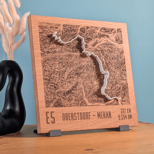
Gifts for hikers show the trail that was walked: the E5 from Oberstdorf to Merano, the Merano High Trail, the Berliner Höhenweg or the Alta Via 1 as a mountain relief with the route as a raised line. Plus single summits such as the Zugspitze via the Reintal valley.
-
Mountain Model Track | Alps Crossing | E5 - Oberstdorf - Merano
通常価格 $182.00 CADから通常価格単価 あたり -
Mountain Model Track | Alps Crossing | Tegernsee - Sterzing
通常価格 $182.00 CADから通常価格単価 あたり -
TrailMap | E5 - Oberstdorf - Merano
通常価格 $279.00 CAD通常価格単価 あたり -
Mountain Model Track | Zugspitze via Reintal
通常価格 $156.00 CADから通常価格単価 あたり -
Mountain Model Track | Meraner Höhenweg
通常価格 $156.00 CADから通常価格単価 あたり -
Mountain Model Track | Alps Crossing | Munich - Venice
通常価格 $238.00 CADから通常価格単価 あたり -
Mountain Model Classic | Rofanspitze
通常価格 $129.00 CADから通常価格単価 あたり -
Mountain Model Track | Tour du Mont Blanc
通常価格 $156.00 CADから通常価格単価 あたり -
Mountain Model Track | Berliner Höhenweg
通常価格 $156.00 CADから通常価格単価 あたり -
Mountain Model Track | SwissPeaks Trail | 2026
通常価格 $200.00 CADから通常価格単価 あたり -
Mountain Model Track | TAR - Transalpine Run | 2026
通常価格 $200.00 CADから通常価格単価 あたり -
Mountain Model Track | Alps Crossing | Munich - Lake Garda
通常価格 $238.00 CADから通常価格単価 あたり -
Mountain Model Track | Alta Via 1
通常価格 $156.00 CADから通常価格単価 あたり -
Mountain Model Natural | Berliner Höhenweg
通常価格 $252.00 CADから通常価格単価 あたり




Which relief suits which hike
The Relief Track is made for a specific tour: the route you walked lies raised on the terrain. A single summit without a line becomes a Relief Classic, printed in one color. The TrailMap shows contour lines laser engraved in solid oak, with the route on top as a raised 3D printed line.
Crossing the Alps on foot
In its alpine section, the European long-distance path E5 leads via Oberstdorf to the Kemptner Hut and across the Lechtal Alps to the Memminger Hut. The stretch from Oberstdorf to Merano is available as a Relief Track and as a TrailMap. Ludwig Grassler described the route from Munich to Venice in a book in 1977, from Marienplatz to St. Mark’s Square in about 28 days of hiking; we carry it as Alps crossing Munich to Venice. Also in the range: Lake Tegernsee to Sterzing and Munich to Lake Garda.
High trails from hut to hut
The Berliner Höhenweg is a high alpine circular trail in the Zillertal Alps starting from Mayrhofen; together with the Aschaffenburger Höhenweg it is promoted as the Zillertal Circuit. The Merano High Trail runs around the Texel group in South Tyrol, and its highest point is the Eisjöchl at 2,895 m. The northern section calls for the fitness of high alpine tours, while less experienced hikers can manage the southern part. The Alta Via 1 runs in 9 to 13 daily stages from Lake Braies to Belluno. The Tour du Mont Blanc leads through France, Italy and Switzerland, usually in seven to ten days around the Mont Blanc massif.
A summit as the goal
Three normal routes lead up Germany’s highest mountain, the Zugspitze at 2,962 m, one of them from the southeast through the Reintal valley. The relief Zugspitze via Reintal shows this route. As a Relief Classic there is the Rofanspitze, at 2,259 m the third-highest summit in the Rofan Mountains in Tyrol and a much-climbed viewpoint from the Erfurter Hut.
Your own tour, engraving and gift card
Your own hike goes onto the relief as a GPX file via Relief Track with your own route, made from real elevation data and handmade in the Bavarian Alps. Without a route, you choose the area in the live 3D configurator. The optional engraving in the oak or stone pine base carries, for example, the tour name, the summit day or coordinates. If it is not clear yet which tour it should be, there is the gift card. Fitting occasions: a completed crossing of the Alps, retirement, an anniversary.
Can I turn my own hike into a relief?
Yes. In the Relief Track you upload the tour as GPX or add a link from Strava, Komoot or Garmin. The route then stands as a raised 3D line on the terrain. The track can also be sent by email after ordering.
Does a multi-day hike fit on one relief?
Yes. In the configurator you place the area so that the whole route fits on it. For long trails like the E5, the large formats up to 28 × 28 cm work well.
What do you engrave for a hike?
The laser engraving is permanent in the wooden base: up to three lines, on Base and Wall alike. Everything is engraved exactly as entered. Common choices are the tour name and year, plus kilometers and elevation gain or the names of fellow hikers.
Are well-known hiking trails available ready-made?
Yes, among others the E5 from Oberstdorf to Merano, the Merano High Trail, the Berliner Höhenweg and the Alta Via 1. They are in this collection with the route marked on them.
More collections
Similar pages: Gifts for mountaineers, Gifts for trail runners, Zillertal Alps, Dolomites, Wetterstein Mountains, Crossing the Alps and Mountain vacation souvenir.