Hohe Tauern as a 3D Relief
Handmade in the Bavarian Alps.
The Hohe Tauern region holds the Grossglockner, the highest mountain in Austria, and the Grossvenediger, the highest in Salzburg. Both are available here as mountain reliefs, and their normal routes and the Grossglockner Ultratrail 2026 as Track.
-
Mountain Model Classic | Großglockner
通常価格 $129.00 CADから通常価格単価 あたり -
Mountain Model Classic | Großvenediger
通常価格 $129.00 CADから通常価格単価 あたり -
Mountain Model Track | Großglockner normal route
通常価格 $156.00 CADから通常価格単価 あたり -
Mountain Model Track | Großglockner Ultratrail | 2026
通常価格 $200.00 CADから通常価格単価 あたり -
TrailMap | GGUT 110K | 2024 - Großglockner Ultratrail
通常価格 $279.00 CAD通常価格単価 あたり -
Mountain Model Track | Großvenediger normal route
通常価格 $156.00 CADから通常価格単価 あたり

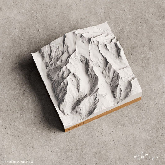

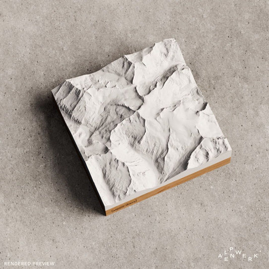


Hohe Tauern: Glockner and Venediger as a 3D model
Salzburg, Carinthia and East Tyrol share most of this high mountain region of the Central Alps, and its southwestern edge belongs to South Tyrol. Its main ridge marks the border between Salzburg and the other two states and is considered the geographic center of the Eastern Alps. From west to east, the Hohe Tauern divide into the Venediger group, Granatspitze group, Glockner group, Goldberg group and Ankogel group. At the center lies the Hohe Tauern National Park, at 1,836 km² the largest of Austria's six national parks and the largest in the Alps. Carinthia declared the first areas a national park in 1981, Salzburg followed in 1983, and the East Tyrol part was added in 1991.
Grossglockner and Grossvenediger
At around 3,798 m, the Grossglockner is the highest mountain in Austria; it is considered one of the most important summits of the Eastern Alps. It belongs to the Glockner ridge in the Glockner group, and the main villages on the mountain are Kals am Großglockner in East Tyrol and Heiligenblut in Carinthia. It was first climbed in 1800 by four members of an expedition led by Prince-Bishop Salm-Reifferscheidt-Krautheim. The Grossvenediger reaches 3,657 m and is the highest mountain of the Venediger group and of Salzburg. It lies directly on the main Alpine ridge between East Tyrol and Salzburg, surrounded by glaciers such as the Schlatenkees and the Obersulzbachkees. On September 3, 1841, a group led by Josef Schwab stood on top for the first time; in the 1980s the summit was still measured at 3,674 m.
Normal routes and huts in the Hohe Tauern
On the Grossglockner, the normal route follows the path of the first ascensionists of 1800 and, at grade II, is considered relatively easy. The starting point is the Adlersruhe with the Erzherzog-Johann-Hütte at 3,454 m, the highest mountain hut in Austria. The route goes up the Glocknerleitl to the Kleinglockner and across the narrow Obere Glocknerscharte to the summit. For the Grossvenediger there are three normal routes as high alpine tours: the southern ascent from the Defreggerhaus is considered one of the easiest, and the eastern ascent leads via the Neue Prager Hütte and the Schlatenkees.
Reliefs from the Hohe Tauern
Classic shows the terrain in a single color; Track also places the route in the model as a raised line.
Your own area of the Hohe Tauern
Krimml Waterfalls, Pasterze or Ankogel group not included? The live 3D configurator cuts any area you want, and a GPX file of your high alpine tour becomes a Track relief. We build every piece by hand in our workshop in the Bavarian Alps, and the relief follows real elevation data. The base comes in oak or stone pine, and engraving is optional.
The Hohe Tauern as a gift
Adlersruhe, Kleinglockner, Defreggerhaus: a relief of the Glockner or the Venediger reminds a rope team of their summit day and runners of their race. If the mountain is still open, the gift card is the simple solution.
Are the Grossglockner and Grossvenediger available as a 3D relief?
Yes, both are available in a single color as Relief Classic and each with its normal route as Track, on which the route runs as a raised line. For runners there are also the Grossglockner Ultratrail 2026 as a Track relief and the TrailMap of the GGUT 110K 2024.
Can I choose the Pasterze or the Krimml Waterfalls as my own area?
Yes. In the live 3D configurator you search for the Pasterze, the Krimml Waterfalls or the Ankogel group by name and set the area by moving it. Before you order, the preview shows you the relief from all sides. Sizes range from 10 × 10 cm to 28 × 28 cm.
Can my own high alpine tour in the Hohe Tauern go on the relief?
Yes, with the custom Relief Track. You upload the recording as a GPX file or add a link from Strava, Komoot or Garmin. The route is modeled as a raised 3D line, not printed on, in red or white. Up to two tracks fit on one relief.
Are the Hohe Tauern also available in color with snow?
Yes, as Relief Natural. Forest, meadow, rock, water and snow appear in true-to-nature coloring, and you decide yourself where the snow line lies. You also choose summer or winter mode, for the Glockner, the Venediger or any other area of the Hohe Tauern.
More collections near the Hohe Tauern
West of the Birnlücke begin the Zillertal Alps, and besides the Hohe Tauern, the Ötztal Alps hold the highest mountains in Austria. Matching ideas are collected in gifts for mountaineers and gifts for trail runners.
Your own area?
Design any summit and any tour yourself, live in 3D.