


TrailMap Oberaudorf Trail Festival | 2026
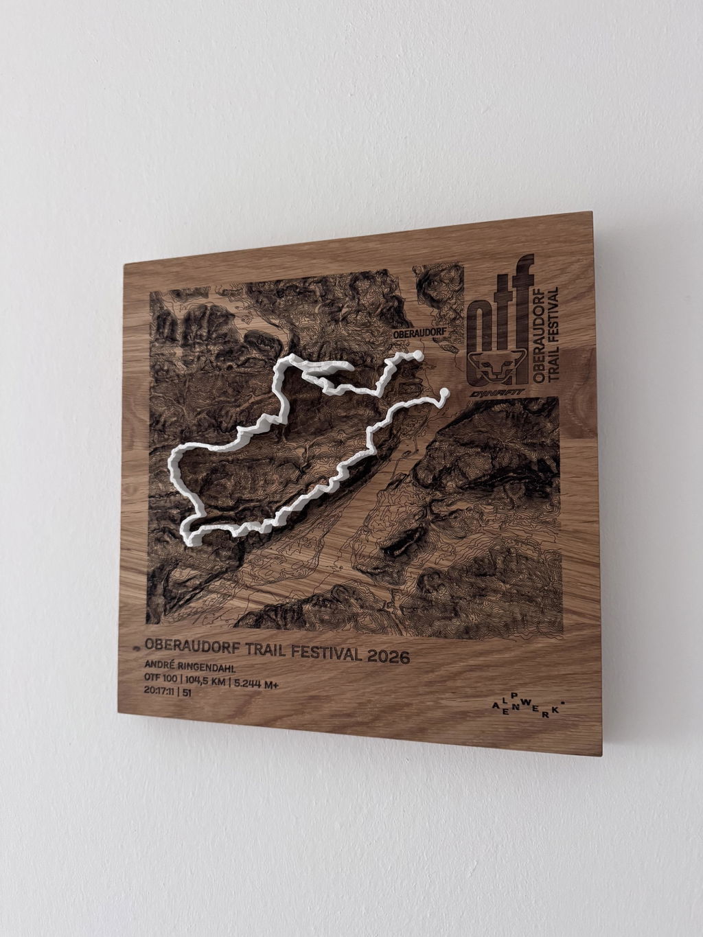
Solid oak with laser-engraved contour lines, your route as a raised line in the color of your choice on top, checkpoint names on request. Cartography for the wall.
Configure your TrailMap
Dein Gipfelmoment, für immer greifbar.
Maßstabsgetreu neben DIN A4, gewählt: . 30 × 30 cm oak, larger than an A4 sheet, approx. 2 cm thick. Version: engraved contour lines.
White stands out with the most contrast on the oiled oak.
Deine Gravur
Wird 1:1 so graviert, wie Du es hier einträgst.
Jede TrailMap ist ein handgefertigtes Unikat, exakt nach Deinen Wünschen graviert. Und wenn doch etwas nicht passt, finden wir eine Lösung, versprochen.
47.6646° N · 12.6463° E · Workshop in the Bavarian Alps
Unsicher bei Größe oder Ausschnitt? Schreib uns. Wir helfen persönlich.
When will your TrailMap arrive?
Zoll und Einfuhrsteuern inklusive für USA, UK, Schweiz, Liechtenstein, Norwegen, Andorra, Australien und Neuseeland.
What you get.
Engraved and raised
The contour lines are laser-engraved into the oiled oak, and the route sits on top as a raised line in the color of your choice: flatter and more cartographic than Mountain Model Track.
Accurate to the millimeter
Exact LiDAR elevation data from the state surveying offices, measured by laser, accurate to 0.5 m.
Checkpoints & names
Place names along the route and finisher engraving, typical for event editions.
Solid oak
30 × 30 cm, oiled, PEFC, with a hanger for the wall.
Planning an event edition?
Finisher trophies with event badge, checkpoint engraving and serial numbering, volume discount from 10 pieces, logo engraving and branding included.
About this TrailMap
Oberaudorf Trail Festival 2026 in the Inn Valley. This TrailMap shows your route as a map on solid oak: contour lines and place names engraved, the course as a raised 3D print. alpen-werk is an official partner of the Oberaudorf Trail Festival and makes the winner trophies.
Four days of trail running in Oberaudorf
From 01 to 04.10.2026, five routes start in the Kurpark Oberaudorf: on Wildbarren and Brünnstein, over the Sudelfeld and around the Wendelstein. The OTF 100 begins in Kiefersfelden and crosses the border into Tyrol.
The 2026 routes
- OTF 100 XXL: 104.5 km, 4,992 m of ascent
- Wendelstein Ultra XL: 56.5 km, 3,228 m of ascent
- Sudelfeld Trail L: 42.8 km, 2,395 m of ascent
- Brünnstein Speed M: 24 km, 1,473 m of ascent
- Hocheck Short S: 12.4 km, 506 m of ascent
TrailMap Oberaudorf Trail Festival: data
- Data basis: official route on precise LiDAR elevation data
- Board: solid oak, oiled, with a wall hanger on the back
- Map: contour lines, place names and event logo laser engraved
- Track: 3D print in PLA, raised on top, color selectable
- Sizes: 30x30 cm and 20x20 cm
- Engraving: route and elevation gain plus your name, your time and your placing
- Production: handmade in the Bavarian Alps
- Price depends on size and version
Oberaudorf Trail Festival as a gift
For your route at the OTF: you choose the size and track color yourself.
Hat seinen Platz gefunden und wird bestimmt nicht das letzte bleiben.
Questions & answers.
01What is the difference to Mountain Model Track?
Mountain Model Track models your tour as a raised 3D line on the printed model. The TrailMap engraves the contour lines flat into solid oak and places your route on top as a raised line in the color of your choice: a cartographic look, ideal for events and checkpoint names.
02What does LiDAR mean, and why does it make your model so accurate?
LiDAR is airborne laser surveying: an aircraft scans the terrain with millions of laser points, and the official state surveying offices turn them into an elevation model with a resolution of up to 0.5 m. This is exactly the data your model is based on, which is why every ridge, every gully and every summit sits exactly where it really is. Freely available satellite elevation data only resolves to 30 m, which is 60 times coarser. On top of that, we prepare every dataset for 3D printing in a dedicated quality step: cleaned, smoothed, with sharp rock edges and without digital artifacts.
03Which routes work?
Any GPX route, from a trail run to a Transalp to your home loop. A Komoot link, your Strava login or a GPX file you upload yourself is all it takes.
04What can be engraved?
Route, contour lines, checkpoint names along the route, finisher name and time, and for event editions also the organizer's logo as a single-color engraving.
05How long does delivery take?
Standard: 3 to 8 business days production plus shipping 1 to 7 business days. Express: 2 to 4 business days plus express shipping 1 to 2 business days. For the US, UK, Switzerland, Liechtenstein, Norway, Andorra, Australia and New Zealand, customs duties and import taxes are included (DDP).
06Is there a volume discount for events?
Yes, from 10 pieces, with logo engraving and custom branding included. Commission models for clubs are possible too. Get in touch via the B2B inquiry.
07What if something isn't right?
Every TrailMap is made to order (no right of withdrawal under §312g of the German Civil Code). If something isn't right, we will find a solution. That's a promise.
Technical data.
- Line
- TrailMap · engraved oak, raised route
- Format
- 30 × 30 cm · Fixed price
- Version
- Engraved contour lines + route
- Track colors
- White · Light gray · Anthracite · Black
- Material
- Solid oak, oiled (PEFC)
- Mounting
- Hanger for the wall
- Elevation data
- LiDAR elevation data from the official state surveying offices, measured by laser, accurate to 0.5 m
- Precision
- More precise than models made from freely available elevation data