

Allgäu Alps as a 3D Relief
Handmade in the Bavarian Alps.
Hochvogel, Nebelhorn, Widderstein and the Alpine crossing on the E5 from Oberstdorf: we offer the Allgäu Alps as a 3D relief made from real elevation data. Any other area of the region you design yourself in the live 3D configurator.
-
Mountain Model Classic | Oberstdorf
Normal price From $179.00 AUDNormal priceBase price for -
Mountain Model Classic | Nebelhorn
Normal price From $179.00 AUDNormal priceBase price for -
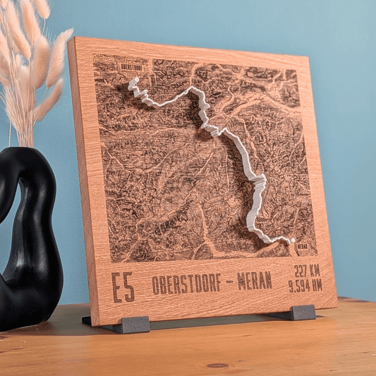
Mountain Model Track | Alps Crossing | E5 - Oberstdorf - Merano
Normal price From $259.00 AUDNormal priceBase price for -
Mountain Model Classic | Hochvogel
Normal price From $179.00 AUDNormal priceBase price for -
Mountain Model Classic | Säuling
Normal price From $179.00 AUDNormal priceBase price for -
Mountain Model Classic | Großer and Kleiner Widderstein
Normal price From $179.00 AUDNormal priceBase price for -
TrailMap | E5 - Oberstdorf - Merano
Normal price $369.00 AUDNormal priceBase price for -
TrailMap | Trail Trophy | 2025
Normal price $369.00 AUDNormal priceBase price for -
Road Bike Mountain Model | Tannheimer Tal 2026
Normal price From $279.00 AUDNormal priceBase price for




The Allgäu Alps: grassy mountains and long valleys
East of Lake Constance lie the Allgäu Alps, a mountain group of the northern Eastern Alps measuring about 75 by 50 kilometers, with parts in Bavaria, Vorarlberg and Tyrol. Their character comes from steep grassy mountains of Lias rock with flanks of up to 70 degrees. The main ridge does not run through the middle but along the southern and southeastern edge; the valleys that lead up to it from the north are therefore longer than those in the south. A mountain relief shows this asymmetry at a glance.
Peaks of the Allgäu Alps
The highest peak is the Großer Krottenkopf at 2,656 m in the Hornbach chain. On the central main ridge rises the trio of Trettachspitze (2,595 m), Mädelegabel (2,645 m) and Hochfrottspitze (2,649 m); the Hochfrottspitze is also the highest summit of Oberstdorf. The Hochvogel, 2,592 m, stands alone in the eastern part of the group and is considered its most beautifully shaped mountain. The Höfats at 2,258 m is regarded as one of the landmarks of the Allgäu Alps. The Nebelhorn (2,224 m) can be reached from Oberstdorf on the Nebelhornbahn cable car; it is the highest point in the Allgäu Alps accessible by cable car. On the southern rim of the Kleinwalsertal stands the Großer Widderstein at 2,533 m; its first recorded ascent was made by the parish priest Bickel in the 17th century.
High trails and huts
The high trails from hut to hut are famous: you can be on the move for seven to ten days without descending into an inhabited valley. The Heilbronner Weg, opened in 1899, leads from the Rappenseehütte, the largest hut in the group, to the Kemptner Hütte. The E5 long-distance trail climbs from Oberstdorf to the Kemptner Hütte and crosses the border into Austria at the Unteres Mädelejoch, at 1,974 m its highest point in the Allgäu Alps.
The Allgäu Alps as a ready-made relief
- In a single color as Classic: Oberstdorf, Nebelhorn, Hochvogel and Großer and Kleiner Widderstein, which are separated by the Karlstor.
- From the neighboring Ammergau Alps: the Säuling, 2,047 m, one of the landmarks of the area between Füssen and Pfronten.
- Two routes are available as Track reliefs with a raised line: the Alpine crossing on the E5 from Oberstdorf to Merano and the road bike relief Tannheimer Tal 2026.
The Tannheimer Tal is a high valley at around 1,100 m in the Tannheim Mountains, about 20 kilometers long and reachable from all sides only via passes, including the Oberjoch Pass and the Gaicht Pass.
Your own area in the Allgäu
If your favorite mountain is missing, you set the area yourself in the live 3D configurator, for example around the Gottesacker plateau or the Vilsalpsee. Upload your own tour, such as the Heilbronner Weg, as a GPX file to the custom Track relief. Every piece is made by hand in the Bavarian Alps and mounted on an oak or stone pine base, with optional engraving.
An Allgäu relief makes a gift for people who live in Oberstdorf, who have walked the E5 or whose summers belong to the huts along the main ridge. If the recipient should choose, the gift card is the right way.
Which mountains of the Allgäu Alps are available as a ready-made 3D relief?
Oberstdorf, Nebelhorn, Hochvogel and Großer and Kleiner Widderstein are available as a single-color Relief Classic, plus the Säuling from the neighboring Ammergau Alps. As Track with a raised line there are the E5 from Oberstdorf to Merano and the road bike relief Tannheimer Tal 2026, and as TrailMap the E5 and the Trail Trophy 2025.
Can I choose my own area in the Allgäu?
Yes. In the live 3D configurator you search for a place by name, such as the Gottesacker plateau or the Vilsalpsee, and move the area until it fits. The preview shows the relief from all sides before you order.
Can my tour through the Allgäu Alps go on the relief, for example the Heilbronner Weg?
Yes, with the Relief Track. You upload the recording as a GPX file or add a link from Strava, Komoot or Garmin. The route is modeled as a raised 3D line in red or white, not printed on. You can also send the track by email after ordering.
Are the Allgäu Alps also available in color with snow?
Yes, as Relief Natural. It shows your chosen area of the Allgäu Alps in multiple colors with true-to-nature coloring: forest, meadow, rock, water and snow. You set the snow line yourself and choose between summer and winter mode.
More collections
Related: Wetterstein Mountains and Zugspitze, gifts for hikers, gifts for road cyclists and the overview of Track reliefs with your own route.